The data that goes into Massachusetts' town-by-town coronavirus risk map is being revamped Friday, the Department of Public Health said ahead of the map's release.
The new data will account for population size, putting just 19 Massachusetts communities in the red category that signifies high risk for COVID-19 transmission, officials said. In last week's report, there were 121 communities in the red, which is more than one-third of all the state's cities and towns.
This week, there will also be 91 communities in yellow, 79 green and 165 in the lowest-risk grey category. The data itself has yet to be released.
It's the third time the map has changed in as many weeks. Its release was pushed back to Friday on Thursday afternoon, hours before it was supposed to be released.
Download our free mobile app for
iOS or Android to get the latest breaking news and in-depth coverage of COVID-19.
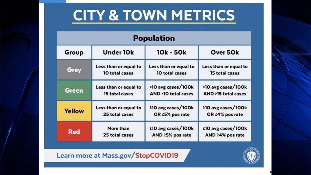
To qualify for the red category under the new metrics, communities with populations under 10,000 must have more than 25 cases. For mid-size communities of between 10,000 and 50,000 people, they must have an average of more than 10 cases per 100,000 people and a positive test rate of more than 5%. And for larger communities of greater than 50,000 people, they must have more than 10 cases per 100,000 people and a positive test rate of more than 4%.

Massachusetts' new metrics for high risk of coronavirus transmission, effective Friday, Nov. 6, 2020.
Under the old metrics, communities with more than 8 cases per 100,000 translated to being high risk and having a red shading on the map.
Friday's change better accounts for communities that test at higher rates, officials said.
"The new metric is informed by data used around the country, including other states in the northeast and mid-Atlantic region," Secretary of Health and Human Services Marylou Sudders said at a news conference Friday.
She and other officials tied the change to keeping students in school. Schools are expected to go remote only if their community is in red, though control is ultimately left up to local officials.
"This is another example, based on a growing body of evidence, that says that schools are not spreaders," Gov. Charlie Baker said.
The number of cities in the red on the coronavirus risk map had been rising rapidly in the last month. Last week's 121 communities was a 57% rise from the 77 the week before.
The Link LonkNovember 07, 2020 at 04:44AM
https://www.nbcboston.com/news/coronavirus/mass-town-by-town-covid-map-changes-again-leaving-far-fewer-communities-in-red/2225165/
Mass. Town-by-Town COVID Map Changes Again, Leaving Far Fewer Communities in Red - NBC10 Boston
https://news.google.com/search?q=Red&hl=en-US&gl=US&ceid=US:en

No comments:
Post a Comment